Devastating Tropical Storm Debby Swamp Southeastern US
Charleston, South Carolina – As Tropical Storm Debby crawls up the eastern seaboard of the United States, it has left a path of destruction in its wake, flooding cities from South Carolina to Georgia, and generating tornadoes. With top speeds recorded at just 3 mph, the storm the potential to lash several coastal cities with over two feet of rain seems imminent.
Debby’s Slow March
The National Hurricane Center announced in a recent advisory that Tropical Storm Debby had slowed down dramatically, now moving at just 3 mph. At this slow pace, the tropical storm looks set to gather more energy from the warm waters of the Atlantic, thereby increasing the risk of further flooding in the Southeast and Northeast.
Having made landfall on the Big Bend of Florida on Monday as a Category 1 hurricane, Debby brought along more than 20 inches of rain, intense storm surge flooding in Southwest Florida, and power outages affecting over 300,000 Floridian customers. The storm is now poised to progress northeastward.
Emergency Measures
President Joe Biden has declared an emergency in Georgia and ensured federal assistance for state and local response efforts due to the adverse conditions caused by Debby. The Weather Prediction Center (WPC) has declared a Level 4 flood risk, the highest threat on its scale, for the upcoming three days impacting various cities in the southeastern parts of the states of Georgia, South Carolina, and North Carolina respectively.
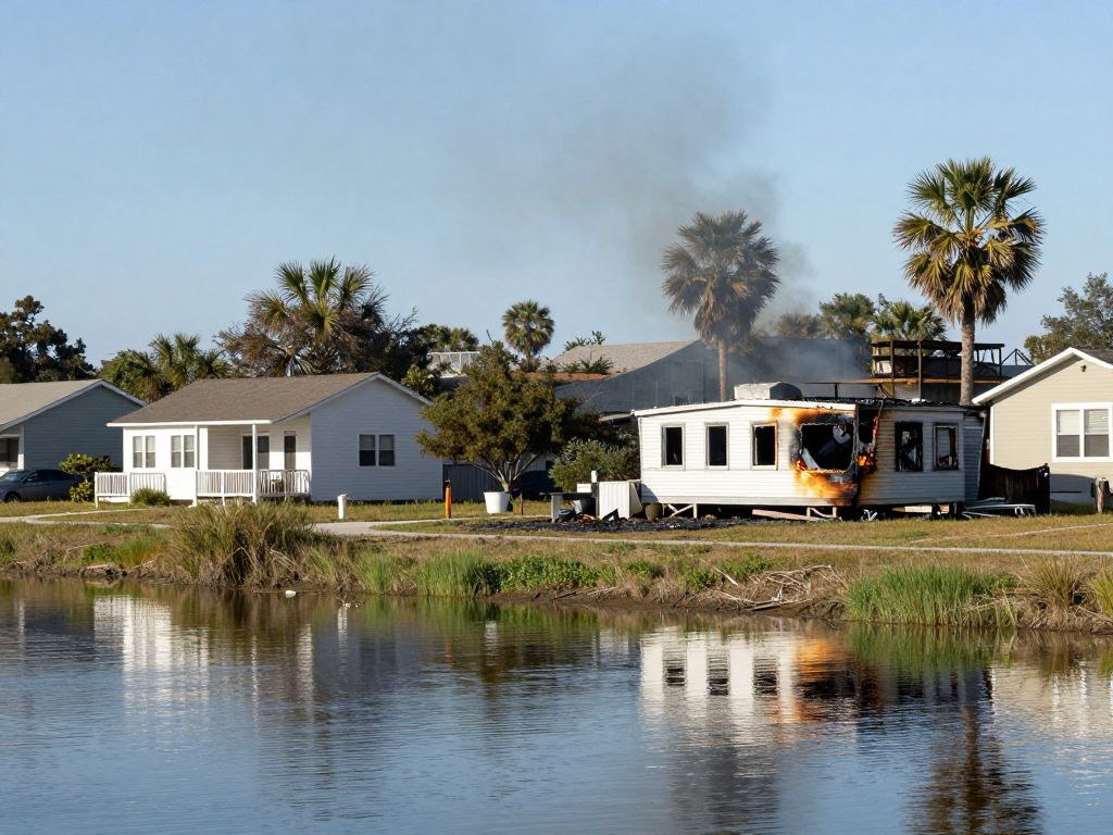
From Surges to Tornadoes: Debby’s Destructive Forces
An offshoot of Debby’s wrath was felt in Moncks Corner, South Carolina, where a tornado thundered through on Monday evening. This devastating event led to the destruction of several businesses and caused extensive damage to countless others. Downed trees and power poles were strewn about, with some landing on vehicles, and at least one car was flipped over due to the tornado’s impact.
Residents in Charleston, South Carolina took, to bundling sandbags in preparation for Debby’s oncoming winds and rain. While storm clouds from Debby were seen ominously hanging over Ocean Isle Beach in North Carolina.
On Tuesday morning, the consequences of a tornado were plain to see on Edisto Beach, South Carolina, as Debby advanced toward the area. Nearby, the police at Isle of Palms, South Carolina, shared pictures of the damage rendered by Debby, highlighting the flooded roads and debris scattered after heavy rainfall and damaging winds ravaged the area early Tuesday morning.
In the Midst of Crisis: Swift Water Rescues in Georgia
Emergency teams were hard at work in Georgia, carrying out swift water rescues, particularly after an incident where a car mistakenly drove into a flooded area in Jeff Davis County. As the rain continues to fall relentlessly throughout Tuesday, the National Weather Service had to issue several Flash Flood Warnings over southeastern Georgia and eastern South Carolina.
Dire Predictions
As forecast models for Debby predict an outward trajectory into the Atlantic Ocean, there’s the possibility of the storm gaining further strength. Despite this, projections still maintain that Debby will remain a tropical storm. Cities in the spotlight over the coming days include Savannah, Myrtle Beach, and Wilmington, all of which are bracing for more than a foot of rain through Thursday. Notably, Charleston, South Carolina, seems to be in line for a substantial downpour, which could exceed two and a half feet.
Emergency Proclamations and Precautions
In the run-up to Debby’s impact, state officials hurried to mobilize resources and ready their constituents. Both South Carolina Gov. Henry McMaster and Georgia Gov. Brian Kemp declared states of emergency, urging all residents to prepare for significant rainfall and assuring them of National Guard resources to help manage the potentially extreme flooding impacts. Similarly, North Carolina Gov. Roy Cooper declared a state of emergency on Monday afternoon.
What Comes Next
According to forecast predictions from the National Hurricane Center, Debby may start to move past the United States’ southeastern coast by late Tuesday, only to be pushed back inland over South Carolina on Thursday. Catastrophic flooding is expected in several regions, as the tropical storm is expected to remain over southeastern U.S. for an extended period due to its slow-motion progress. With that in mind, city officials and residents alike are doing their best to prepare for the worst, even as they hope for the best.

Author: STAFF HERE MYRTLE BEACH
The HERE Myrtle Beach Staff Writers are a collaborative team of journalists, editors, and local contributors passionate about delivering accurate, timely information to the Myrtle Beach community. As part of the HEREcity.com Network, which powers over 100 U.S. city sites including HEREcolumbia.com, our staff draws on collective experience in South Carolina journalism to cover everything from business sales and real estate developments to dining deals and community initiatives. Our Expertise and Background Local Roots in Myrtle Beach Our team includes lifelong Myrtle Beach residents and SC natives with deep knowledge of the area’s history, economy, and culture. We’ve covered key events like the recent developments along the Grand Strand, Myrtle Beach’s tourism and hospitality industry, and growth in local education sectors (e.g., Coastal Carolina University programs). Collective Experience With over 50 combined years in journalism, our staff has backgrounds in print, digital media, and community reporting. We prioritize fact-based stories, drawing from sources like the Myrtle Beach Area Chamber of Commerce, city government records, and on-the-ground interviews. Commitment to Quality Every article is a group effort, involving research, editing, and verification to ensure reliability. We adhere to journalistic standards, citing credible sources and updating content as new details emerge.