Myrtle Beach, January 29, 2026
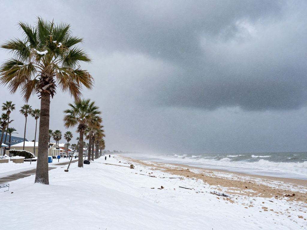
Myrtle Beach is preparing for the potential impacts of a powerful nor’easter, Winter Storm Gianna, expected to bring heavy snow, strong winds, and coastal flooding. The storm’s arrival, anticipated from late Saturday through Sunday, poses significant threats, particularly to the coastal Carolinas and southern Virginia. Residents are advised to prepare for hazardous travel conditions, power outages, and potential blizzard-like conditions as the storm evolves into a ‘bomb cyclone.’
Myrtle Beach braces for powerful Nor’easter this weekend
A potent nor’easter, named Winter Storm Gianna, is poised to impact the Carolinas, including Myrtle Beach, from late Saturday through Sunday, January 31st to February 1st, 2026. This significant winter storm is expected to bring heavy snow, strong winds, and the potential for coastal flooding, with some areas facing blizzard-like conditions. Communities across the East Coast, from the Southeast to New England, are bracing for the storm’s arrival, which is forecast to rapidly intensify into a “bomb cyclone” off the Carolina coast.
Immediate Threat and Impact Zones
The storm’s formation near the Carolina coast on Saturday, January 31st, will usher in a severe weather pattern before it tracks northward on Sunday, February 1st. A Winter Storm Watch has been issued for the entire area, encompassing counties such as Horry, Georgetown, and Florence in South Carolina, and Brunswick, New Hanover, and Pender in North Carolina.
Areas most likely to experience the storm’s full wrath include the coastal Carolinas and southern Virginia, where forecasters have expressed high confidence in significant snowfall. Specifically, the Outer Banks of North Carolina could receive nearly a foot of snow, accompanied by damaging wind gusts reaching 70 to 80 mph. Along the coast, winds are generally expected to be in the 30-50 mph range, with potential for gusts up to 50-70 mph, particularly from Surf City, NC, to Little River Inlet, SC. These intense winds will contribute to waves of 15 to 30 feet offshore late Saturday into Sunday, elevating the risk of coastal flooding and erosion. The National Weather Service in Newport/Morehead City, North Carolina, noted that the coastal flooding impacts would be exacerbated by a higher tide cycle.
Inland regions of the Carolinas are also expected to see substantial snowfall. Swaths of 3 to 6 inches are likely across eastern Tennessee, northern and eastern Georgia, and most of the Carolinas, with localized totals exceeding 6 inches possible in pockets of North Carolina, especially along the Outer Banks. Cities such as Charlotte and Raleigh, North Carolina, are predicted to receive 5-8 inches of snow, while light snow is anticipated as far south as Charleston, South Carolina, and North Georgia. Freezing temperatures will create dangerous wind chills in the single digits on Saturday and Sunday nights.
Travel Disruptions and Preparedness
The impending storm carries a high likelihood of causing major travel disruptions. Significant snow is predicted to fall from the Piedmont to the coast, making travel hazardous across the region. Major travel impacts are possible on Saturday at Charlotte Douglas International Airport in North Carolina. With the potential for blizzard-like conditions, residents are advised to monitor local forecasts closely and prepare for possible power outages. The rapidly intensifying nature of this “bomb cyclone” suggests that strong winds could cause power disruptions and tree damage along parts of the East Coast.
Broader Context of Winter Weather
This nor’easter arrives amidst a winter season influenced by a weak La Niña pattern, marking the fourth time in the last six years La Niña has been a factor in the Carolinas’ winter weather. While La Niña typically leads to drier and warmer-than-average winters in central North Carolina, its weaker presence this year allows for more unpredictable outcomes, including occasional colder periods and snowfall. The current storm follows closely on the heels of another significant winter storm, Winter Storm Fern, which impacted widespread areas of the U.S. East Coast earlier in January, causing extensive snowfall, ice accumulations, power outages for over a million customers, and tragically, more than 100 fatalities nationwide. The current system is not expected to be as widespread or intense as the preceding storm, but its coastal impacts are projected to be severe. The exact track of the storm remains a critical variable, with even a 50-mile shift potentially altering the distribution of snow and dry conditions along other parts of the East Coast.
Frequently Asked Questions
What is the primary weather event expected in the Carolinas this weekend?
A powerful nor’easter, named Winter Storm Gianna, is forecast to impact the Carolinas, including Myrtle Beach, from late Saturday through Sunday, January 31st to February 1st, 2026.
What are the main hazards associated with this nor’easter?
The main hazards include heavy snow, strong winds, and the potential for coastal flooding, with some areas facing blizzard-like conditions.
When is the storm expected to affect the region?
The storm is expected to affect the region from late Saturday through Sunday, January 31st to February 1st, 2026.
Which areas are expected to see the heaviest snowfall?
The heaviest snow will fall across the Carolinas, where swaths of 3 to 6 inches are likely, as well as along the coastline from southeast Virginia to southeast Massachusetts, with localized amounts eclipsing 6 inches. The Outer Banks of North Carolina could receive nearly a foot of snow.
What wind speeds are anticipated?
Along the coast, winds are generally expected to be in the 30-50 mph range, with potential for damaging gusts up to 70 to 80 mph in the Outer Banks. Gale force winds are likely over the coastal waters late Saturday into Sunday, with a few gusts up to storm force possible, particularly from Surf City, NC, to Little River Inlet, SC.
What is the risk of coastal flooding?
Intense winds will cause waves of 15 to 30 feet to form offshore late Saturday into Sunday, significantly raising the risk for coastal flooding and damage in the Outer Banks. The coastal flooding impacts would be exacerbated by a higher tide cycle.
Will there be extreme cold temperatures?
Dangerous cold will create wind chills in the single digits on Saturday and Sunday nights.
What is the outlook for travel during the storm?
Major travel impacts are possible on Saturday at Charlotte Douglas International Airport in North Carolina, and significant snow is predicted to disrupt travel across the region.
Key Features of Winter Storm Gianna’s Impact
| Heavy Snowfall | 3 to 6 inches widely, with localized amounts exceeding 6 inches. Nearly a foot in North Carolina’s Outer Banks. Charlotte and Raleigh, NC, expecting 5-8 inches. | Eastern Tennessee, Northern and Eastern Georgia, most of the Carolinas, Coastal Carolinas, Outer Banks of North Carolina, Charlotte, Raleigh, Norfolk, Virginia Beach. |
| Strong Winds | 30-50 mph sustained along the East Coast. Damaging gusts up to 70-80 mph in the Outer Banks. Gale force winds likely over coastal waters, with potential storm force gusts from Surf City, NC, to Little River Inlet, SC. | East Coast, Outer Banks, Coastal Carolinas, Southern Virginia, from Surf City, NC, to Little River Inlet, SC. |
| Coastal Flooding | Waves of 15-30 feet offshore, raising risk for moderate to locally significant coastal flooding and erosion, exacerbated by high tide cycle. | Outer Banks of North Carolina, Mid-Atlantic to New England coast. |
| Blizzard-like Conditions | Potential for periods of reduced visibility and intense snow driven by strong winds. | Southeast to New England, Virginia Beach and Norfolk areas. |
| Dangerous Cold | Wind chills in the single digits. | Carolinas and surrounding areas, Saturday night and Sunday night. |
| Travel Disruptions | Significant snow and strong winds could disrupt air and ground travel. | Charlotte Douglas International Airport, regional roads across the Carolinas and Mid-Atlantic. |
| Storm Classification | Expected to rapidly intensify into a “bomb cyclone” and “double bomb” off the Carolina coast. | East Coast, off the Carolina coast. |
Deeper Dive: News & Info About This Topic
HERE Resources
Unique Coastal Boutique Opens in Myrtle Beach
Art Festival Energizes Myrtle Beach Community
Myrtle Beach Enhances Downtown Safety with New Lighting
Hemingway Chapel Road Closure for Stormwater Project
Myrtle Beach’s Family Fun and Live Music Await
Myrtle Beach’s Vibrant Events: A Catalyst for Community Prosperity
Myrtle Beach: Horry County’s Return to OPCON 3 Powers Local Businesses
Myrtle Beach’s Economic Pulse: Free Food & Fresh Growth
Outdoor Education & Sports Surge in Myrtle Beach Schools
Coastal Carolina University Expands Academic Offerings
Author: STAFF HERE MYRTLE BEACH
The HERE Myrtle Beach Staff Writers are a collaborative team of journalists, editors, and local contributors passionate about delivering accurate, timely information to the Myrtle Beach community. As part of the HEREcity.com Network, which powers over 100 U.S. city sites including HEREcolumbia.com, our staff draws on collective experience in South Carolina journalism to cover everything from business sales and real estate developments to dining deals and community initiatives. Our Expertise and Background Local Roots in Myrtle Beach Our team includes lifelong Myrtle Beach residents and SC natives with deep knowledge of the area’s history, economy, and culture. We’ve covered key events like the recent developments along the Grand Strand, Myrtle Beach’s tourism and hospitality industry, and growth in local education sectors (e.g., Coastal Carolina University programs). Collective Experience With over 50 combined years in journalism, our staff has backgrounds in print, digital media, and community reporting. We prioritize fact-based stories, drawing from sources like the Myrtle Beach Area Chamber of Commerce, city government records, and on-the-ground interviews. Commitment to Quality Every article is a group effort, involving research, editing, and verification to ensure reliability. We adhere to journalistic standards, citing credible sources and updating content as new details emerge.